
Carte topographique Warwick
Carte interactive
Cliquez sur la carte pour afficher l’altitude.
À propos de cette carte
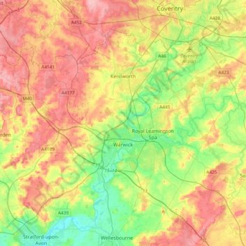
Nom : Carte topographique Warwick, altitude, relief.
Lieu : Warwick, Warwickshire, England, United Kingdom (52.21370 -1.78018 52.38928 -1.40608)
Altitude moyenne : 87 m
Altitude minimum : 35 m
Altitude maximum : 145 m
Warwick experiences the usual English maritime climate, marked by a narrow temperature range, mild winters and cool summers. The nearest official Met Office weather station is at Wellesbourne, about 6 miles (10 km) south of the town centre and at a similar elevation. The absolute maximum temperature (also the absolute maximum for the county of Warwickshire) stands at 36.1 °C (97.0 °F) recorded in August 1990. During a typical year, the warmest day should reach 30.0 °C (86.0 °F), and 16.5 days should report a maximum of 25.1 °C (77.2 °F) or higher. The lowest recorded temperature is −17.8 °C (0.0 °F), recorded in January 1982. Typically, 53.3 air frosts are recorded in an "average" year. Rainfall averages out at 608 millimetres (23.9 in) per year, with over 114 days seeing 1 mm (0.04 in) or more falling. All averages refer to the 1971–2000 period.
Autres cartes topographiques
Cliquez sur une carte pour visualiser sa topographie, son altitude et son relief.
Whitnash
United Kingdom > England > Warwickshire > Warwick
Whitnash, Warwick, Warwickshire, England, United Kingdom
Altitude moyenne : 69 m
Clifton upon Dunsmore CP
United Kingdom > England > Warwickshire > Rugby
Clifton upon Dunsmore CP, Rugby, Warwickshire, England, United Kingdom
Altitude moyenne : 108 m
Draycote Water
United Kingdom > England > Warwickshire > Rugby > Draycote
Draycote Water, Draycote, Rugby, Warwickshire, England, United Kingdom
Altitude moyenne : 92 m
Harbury
United Kingdom > England > Warwickshire > Stratford-on-Avon
Harbury, Stratford-on-Avon, Warwickshire, England, United Kingdom
Altitude moyenne : 95 m
Binton
United Kingdom > England > Warwickshire > Stratford-on-Avon
Binton, Stratford-on-Avon, Warwickshire, England, CV37 9TL, United Kingdom
Altitude moyenne : 60 m
Burton Dassett Hills Country Park
United Kingdom > England > Warwickshire > Stratford-on-Avon > Northend > Burton Dassett CP
Burton Dassett Hills Country Park, Burton Dassett CP, Northend, Stratford-on-Avon, Warwickshire, England, United Kingdom
Altitude moyenne : 132 m
Alveston
United Kingdom > England > Warwickshire > Stratford-on-Avon
Alveston, Stratford-on-Avon, Warwickshire, England, CV37 7QT, United Kingdom
Altitude moyenne : 50 m
Rugby
United Kingdom > England > Warwickshire
Rugby, Warwickshire, England, United Kingdom
Altitude moyenne : 112 m
Alcester
United Kingdom > England > Warwickshire > Stratford-on-Avon
Alcester, Stratford-on-Avon, Warwickshire, England, United Kingdom
Altitude moyenne : 62 m
Nuneaton
United Kingdom > England > Warwickshire > Nuneaton and Bedworth
Nuneaton, Nuneaton and Bedworth, Warwickshire, England, CV11 5AB, United Kingdom
Altitude moyenne : 101 m
Warmington CP
United Kingdom > England > Warwickshire > Stratford-on-Avon
Warmington CP, Stratford-on-Avon, Warwickshire, England, United Kingdom
Altitude moyenne : 145 m
Newton
United Kingdom > England > Warwickshire > Rugby
Newton, Rugby, Warwickshire, England, CV23 0EE, United Kingdom
Altitude moyenne : 114 m
Kineton CP
United Kingdom > England > Warwickshire > Stratford-on-Avon
Kineton CP, Stratford-on-Avon, Warwickshire, England, United Kingdom
Altitude moyenne : 93 m
Cranhill
United Kingdom > England > Warwickshire > Stratford-on-Avon > Ardens Grafton
Cranhill, Temple Grafton CP, Ardens Grafton, Stratford-on-Avon, Warwickshire, England, B50 4LW, United Kingdom
Altitude moyenne : 57 m
Gaydon
United Kingdom > England > Warwickshire > Stratford-on-Avon > Gaydon
Gaydon, Stratford-on-Avon, Warwickshire, England, United Kingdom
Altitude moyenne : 109 m
Bishops Itchington
United Kingdom > England > Warwickshire > Stratford-on-Avon > Bishop's Itchington
Bishops Itchington, Bishop's Itchington, Stratford-on-Avon, Warwickshire, England, United Kingdom
Altitude moyenne : 104 m
Shipston-on-Stour
United Kingdom > England > Warwickshire > Stratford-on-Avon
Shipston-on-Stour, Stratford-on-Avon, Warwickshire, England, CV36 4AJ, United Kingdom
Altitude moyenne : 83 m
Long Marston CP
United Kingdom > England > Warwickshire > Stratford-on-Avon
Long Marston CP, Stratford-on-Avon, Warwickshire, England, United Kingdom
Altitude moyenne : 45 m
Wellesbourne
United Kingdom > England > Warwickshire > Stratford-on-Avon > Wellesbourne
Wellesbourne, Stratford-on-Avon, Warwickshire, England, CV35 9SJ, United Kingdom
Altitude moyenne : 69 m
Cherington
United Kingdom > England > Warwickshire > Stratford-on-Avon
Cherington, Stratford-on-Avon, Warwickshire, England, CV36 5HS, United Kingdom
Altitude moyenne : 119 m
Stratford-upon-Avon
United Kingdom > England > Warwickshire > Stratford-on-Avon
Stratford-upon-Avon, Stratford-on-Avon, Warwickshire, England, United Kingdom
Altitude moyenne : 61 m
Royal Leamington Spa
United Kingdom > England > Warwickshire
Royal Leamington Spa, Warwick, Warwickshire, England, United Kingdom
Altitude moyenne : 66 m
Ullenhall
United Kingdom > England > Warwickshire > Stratford-on-Avon > Ullenhall
Ullenhall, Stratford-on-Avon, Warwickshire, West Midlands, England, United Kingdom
Altitude moyenne : 106 m
Newbold on Avon
United Kingdom > England > Warwickshire > Rugby
Newbold on Avon, Rugby, Warwickshire, England, CV21 1HQ, United Kingdom
Altitude moyenne : 98 m
West Midlands
United Kingdom > England > Warwickshire
West Midlands, Warwickshire, West Midlands Combined Authority, England, United Kingdom
Altitude moyenne : 113 m
Sutton-under-Brailes
United Kingdom > England > Warwickshire > Stratford-on-Avon > Stourton
Sutton-under-Brailes, Sutton under Brailes, Stourton, Stratford-on-Avon, Warwickshire, England, OX15 5BG, United Kingdom
Altitude moyenne : 125 m