
Carte topographique Cadillac Mountain
Carte interactive
Cliquez sur la carte pour afficher l’altitude.
À propos de cette carte
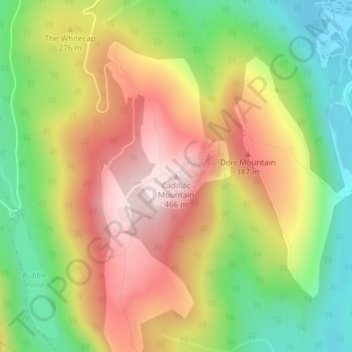
Nom : Carte topographique Cadillac Mountain, altitude, relief.
Altitude moyenne : 233 m
Altitude minimum : 15 m
Altitude maximum : 461 m
Cadillac Mountain is located on Mount Desert Island, within Acadia National Park, in the U.S. state of Maine. With an elevation of 1,530 feet (470 meters), its summit is the highest point in Hancock County and the highest within 25 miles (40 km) of the Atlantic shoreline of the North American continent between the Cape Breton Highlands, Nova Scotia, and peaks in Mexico. It is known as the first place in the continental U.S. to see the sunrise, although that is only true for a portion of the year.
Autres cartes topographiques
Cliquez sur une carte pour visualiser sa topographie, son altitude et son relief.
Acadia National Park
United States > Maine > Hancock County > Bar Harbor
Acadia National Park, Bar Harbor, Hancock County, Maine, 04609, United States
Altitude moyenne : 9 m
Fresh Meadow
United States > Maine > Hancock County > Bar Harbor
Fresh Meadow, Bar Harbor, Hancock County, Maine, United States
Altitude moyenne : 17 m
Salsbury Cove
United States > Maine > Hancock County > Bar Harbor
Salsbury Cove, Bar Harbor, Hancock County, Maine, United States
Altitude moyenne : 15 m