Carte topographique Lind
Carte interactive
Cliquez sur la carte pour afficher l’altitude.
À propos de cette carte
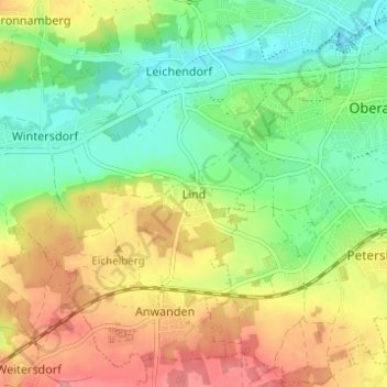
Nom : Carte topographique Lind, altitude, relief.
Lieu : Lind, Zirndorf, Landkreis Fürth, Bayern, 90513, Deutschland (49.40136 10.91655 49.44136 10.95655)
Altitude moyenne : 334 m
Altitude minimum : 295 m
Altitude maximum : 384 m
Autres cartes topographiques
Cliquez sur une carte pour visualiser sa topographie, son altitude et son relief.
Anwanden
Deutschland > Bayern > Landkreis Fürth > Zirndorf
Anwanden, Zirndorf, Landkreis Fürth, Bayern, 90522, Deutschland
Altitude moyenne : 353 m
Weinzierlein
Deutschland > Bayern > Landkreis Fürth > Zirndorf
Weinzierlein, Zirndorf, Landkreis Fürth, Bayern, 90574, Deutschland
Altitude moyenne : 342 m
Bronnamberg
Deutschland > Bayern > Landkreis Fürth > Zirndorf
Bronnamberg, Zirndorf, Landkreis Fürth, Bayern, 90513, Deutschland
Altitude moyenne : 338 m
Wintersdorf
Deutschland > Bayern > Landkreis Fürth > Zirndorf
Wintersdorf, Zirndorf, Landkreis Fürth, Bayern, 90513, Deutschland
Altitude moyenne : 336 m