
Carte topographique Kotdwar
Cliquez sur la carte pour afficher l’altitude.
Kotdwar
Kotdwar lies on the western margin of the Himalayas, at an altitude of 454 m (1,490 ft) above sea level.
À propos de cette carte
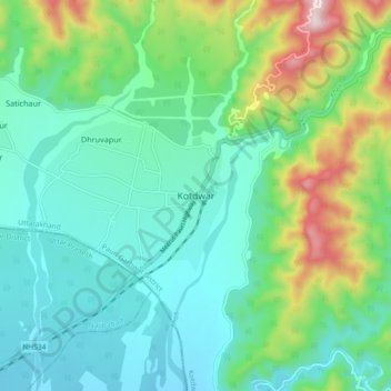
Nom : Carte topographique Kotdwar, altitude, relief.
Lieu : Kotdwar, Kotdwara, Pauri Garhwal, Uttarakhand, 246149, India (29.58598 78.36014 29.90598 78.68014)
Altitude moyenne : 641 m
Altitude minimum : 260 m
Altitude maximum : 1’832 m
Autres cartes topographiques
Cliquez sur une carte pour visualiser sa topographie, son altitude et son relief.
Ramganga Dam
India > Uttarakhand > Kotdwara
The dam is a 128 m (420 ft) tall and 630 m (2,067 ft) long earth and rock-fill embankment dam with 10,000,000 m3 (13,079,506 cu yd) of fill. The dam's spillway is controlled by five gates and has a maximum discharge of 8,467 m3/s (299,009 cu ft/s). To support the reservoir's elevation, there is a 72 m (236 ft)…
Altitude moyenne : 389 m