
Carte topographique Swords
Carte interactive
Cliquez sur la carte pour afficher l’altitude.
À propos de cette carte
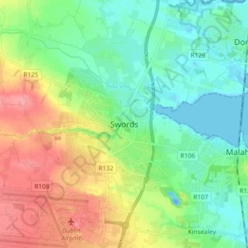
Nom : Carte topographique Swords, altitude, relief.
Lieu : Swords, Fingal, County Dublin, Leinster, K67 X8Y2, Ireland (53.41983 -6.25846 53.49983 -6.17846)
Altitude moyenne : 28 m
Altitude minimum : -19 m
Altitude maximum : 80 m
At the northern end of the street stands Swords Castle, 200m northeast of the ecclesiastical site, which was built in the early 13th century. A short distance north of the Castle is the elevation known as Spittal Hill, where a hospital once stood.