
Faire un don
Équipez-vous pour votre prochaine aventure :
En tant que Partenaire Amazon, ce site perçoit une commission sur les achats éligibles sans surcoût pour vous.
Carte topographique Metu
Cliquez sur la carte pour afficher l’altitude.
Faire un don
Équipez-vous pour votre prochaine aventure :
En tant que Partenaire Amazon, ce site perçoit une commission sur les achats éligibles sans surcoût pour vous.
Metu
Metu (Oromo: Mattuu) is a market town and separate woreda in south-western Ethiopia. Located in the Illubabor Zone of the Oromia along the Sor River, this town has a latitude and longitude of 8°18′N 35°35′E / 8.300°N 35.583°E / 8.300; 35.583 and an altitude of 1605 meters. Metu was the capital of the former Illubabor Province from 1978 until the adoption of the new constitution in 1995.
Faire un don
Équipez-vous pour votre prochaine aventure :
En tant que Partenaire Amazon, ce site perçoit une commission sur les achats éligibles sans surcoût pour vous.
À propos de cette carte
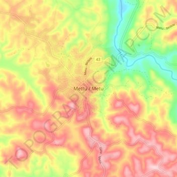
Nom : Carte topographique Metu, altitude, relief.
Lieu : Metu, Illubabor, Oromia Region, Ethiopia (8.25565 35.54343 8.33565 35.62343)
Altitude moyenne : 1’682 m
Altitude minimum : 1’531 m
Altitude maximum : 1’800 m
Faire un don
Équipez-vous pour votre prochaine aventure :
En tant que Partenaire Amazon, ce site perçoit une commission sur les achats éligibles sans surcoût pour vous.
Autres cartes topographiques
Cliquez sur une carte pour visualiser sa topographie, son altitude et son relief.
Asela
Asella (Oromo: Asallaa, Amharic: አሰላ) is a town in central Ethiopia. Located in the Arsi Zone of the Oromia Region 156 km (97 mi) south from Addis Ababa, this town has a latitude and longitude of 7°57′N 39°7′E / 7.950°N 39.117°E / 7.950; 39.117, with an elevation of 2,430 meters. Asella…
Altitude moyenne : 2’429 m
Faire un don
Équipez-vous pour votre prochaine aventure :
En tant que Partenaire Amazon, ce site perçoit une commission sur les achats éligibles sans surcoût pour vous.
Lake Abaya
The only outflow of the lake is through the lower reaches of Kulfo River directly below an alluvial fan at an elevation of 1,190 m (at 6°00′39″N 37°35′07″E / 6.0109°N 37.5854°E / 6.0109; 37.5854). The riverbed acts as an spillway in the case of high lake levels and discharges the excess…
Altitude moyenne : 1’471 m
Asela
Asella (Oromo: Asallaa, Amharic: አሰላ) is a town in central Ethiopia. Located in the Arsi Zone of the Oromia Region 126 km (78 mi) south from Addis Ababa, this town has a latitude and longitude of 7°57′N 39°7′E / 7.950°N 39.117°E / 7.950; 39.117, with an elevation of 2,430 meters. Asella…
Altitude moyenne : 2’429 m
Moyale
Moyale has a hot semi-arid climate (Köppen BSh) moderated somewhat by altitude. Typically for East Africa, there are two rainy seasons: the “long rains” from March to May and the weaker, less reliable “short rains” in October and November.
Altitude moyenne : 1’095 m
Faire un don
Équipez-vous pour votre prochaine aventure :
En tant que Partenaire Amazon, ce site perçoit une commission sur les achats éligibles sans surcoût pour vous.
Harena Forest
The Harenna Forest is a montane tropical evergreen forest in Ethiopia's Bale Mountains. The forest covers the southern slope of the mountains, extending from 1450 to 3200 meters elevation. The Bale Mountains are in Ethiopia's Oromia Region, and form the southwestern portion of the Ethiopian Highlands.
Altitude moyenne : 2’028 m
Faire un don
Équipez-vous pour votre prochaine aventure :
En tant que Partenaire Amazon, ce site perçoit une commission sur les achats éligibles sans surcoût pour vous.
Asela
Asella (Oromo: Asallaa, Amharic: አሰላ) is a town in central Ethiopia. Located in the Arsi Zone of the Oromia Region 126 km (78 mi) south from Addis Ababa, this town has a latitude and longitude of 7°57′N 39°7′E / 7.950°N 39.117°E / 7.950; 39.117, with an elevation of 2,430 meters. Asella…
Altitude moyenne : 2’429 m
Faire un don
Équipez-vous pour votre prochaine aventure :
En tant que Partenaire Amazon, ce site perçoit une commission sur les achats éligibles sans surcoût pour vous.
Faire un don
Équipez-vous pour votre prochaine aventure :
En tant que Partenaire Amazon, ce site perçoit une commission sur les achats éligibles sans surcoût pour vous.