
Carte topographique Isla Salas
Carte interactive
Cliquez sur la carte pour afficher l’altitude.
À propos de cette carte
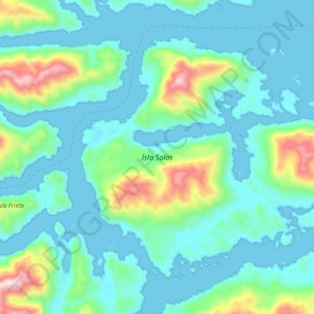
Nom : Carte topographique Isla Salas, altitude, relief.
Altitude moyenne : 144 m
Altitude minimum : -1 m
Altitude maximum : 832 m
Autres cartes topographiques
Cliquez sur une carte pour visualiser sa topographie, son altitude et son relief.
Canal Moraleda
Chile > Región Aysén del General Carlos Ibáñez del Campo > Aysén > Estero Copa
Canal Moraleda, Manuel Rodríguez, Estero Copa, Aysén, Provincia de Aysén, Región Aysén del General Carlos Ibáñez del Campo, Chile
Altitude moyenne : 276 m
Isla Kent
Chile > Región Aysén del General Carlos Ibáñez del Campo > Aysén
Isla Kent, Aysén, Provincia de Aysén, Región Aysén del General Carlos Ibáñez del Campo, Chile
Altitude moyenne : 53 m
Reserva Nacional Las Guaitecas
Chile > Región Aysén del General Carlos Ibáñez del Campo > Aysén
Reserva Nacional Las Guaitecas, Aysén, Provincia de Aysén, Región Aysén del General Carlos Ibáñez del Campo, Chile
Altitude moyenne : 155 m
Isla Nalcayec
Chile > Región Aysén del General Carlos Ibáñez del Campo > Aysén
Isla Nalcayec, Aysén, Provincia de Aysén, Región Aysén del General Carlos Ibáñez del Campo, Chile
Altitude moyenne : 241 m
Península de Taitao
Chile > Región Aysén del General Carlos Ibáñez del Campo > Aysén
Península de Taitao, Aysén, Provincia de Aysén, Región Aysén del General Carlos Ibáñez del Campo, Chile
Altitude moyenne : 616 m
Isla Quillín
Chile > Región Aysén del General Carlos Ibáñez del Campo > Aysén
Isla Quillín, Aysén, Provincia de Aysén, Región Aysén del General Carlos Ibáñez del Campo, Chile
Altitude moyenne : 4 m
Monte San Valentín
Chile > Región Aysén del General Carlos Ibáñez del Campo > Aysén
Monte San Valentín, Aysén, Provincia de Aysén, Región Aysén del General Carlos Ibáñez del Campo, Chile
Altitude moyenne : 3’353 m
Lago Presidente Ríos
Chile > Región Aysén del General Carlos Ibáñez del Campo > Aysén
Lago Presidente Ríos, Aysén, Provincia de Aysén, Región Aysén del General Carlos Ibáñez del Campo, Chile
Altitude moyenne : 224 m
Isla Isquiliac
Chile > Región Aysén del General Carlos Ibáñez del Campo > Aysén
Isla Isquiliac, Aysén, Provincia de Aysén, Región Aysén del General Carlos Ibáñez del Campo, Chile
Altitude moyenne : 167 m
Isla Melchor
Chile > Región Aysén del General Carlos Ibáñez del Campo > Aysén
Isla Melchor, Aysén, Provincia de Aysén, Región Aysén del General Carlos Ibáñez del Campo, Chile
Altitude moyenne : 179 m
Isla Clemente
Chile > Región Aysén del General Carlos Ibáñez del Campo > Aysén
Isla Clemente, Aysén, Provincia de Aysén, Región Aysén del General Carlos Ibáñez del Campo, Chile
Altitude moyenne : 144 m
Isla Quemada
Chile > Región Aysén del General Carlos Ibáñez del Campo > Aysén
Isla Quemada, Aysén, Provincia de Aysén, Región Aysén del General Carlos Ibáñez del Campo, Chile
Altitude moyenne : 165 m
Glaciar San Quintín
Chile > Región Aysén del General Carlos Ibáñez del Campo > Aysén
Glaciar San Quintín, Aysén, Provincia de Aysén, Región Aysén del General Carlos Ibáñez del Campo, Chile
Altitude moyenne : 526 m
Isla Garrido
Chile > Región Aysén del General Carlos Ibáñez del Campo > Aysén
Isla Garrido, Aysén, Provincia de Aysén, Región Aysén del General Carlos Ibáñez del Campo, Chile
Altitude moyenne : 157 m
Lago Yulton
Chile > Región Aysén del General Carlos Ibáñez del Campo > Aysén
Lago Yulton, Aysén, Provincia de Aysén, Región Aysén del General Carlos Ibáñez del Campo, Chile
Altitude moyenne : 676 m
Isla Dring
Chile > Región Aysén del General Carlos Ibáñez del Campo > Aysén
Isla Dring, Aysén, Provincia de Aysén, Región Aysén del General Carlos Ibáñez del Campo, Chile
Altitude moyenne : 161 m
Isla Luz
Chile > Región Aysén del General Carlos Ibáñez del Campo > Aysén
Isla Luz, Aysén, Provincia de Aysén, Región Aysén del General Carlos Ibáñez del Campo, Chile
Altitude moyenne : 135 m
Isla Rivero
Chile > Región Aysén del General Carlos Ibáñez del Campo > Aysén
Isla Rivero, Aysén, Provincia de Aysén, Región Aysén del General Carlos Ibáñez del Campo, Chile
Altitude moyenne : 159 m