
Carte topographique Boyne City
Carte interactive
Cliquez sur la carte pour afficher l’altitude.
À propos de cette carte
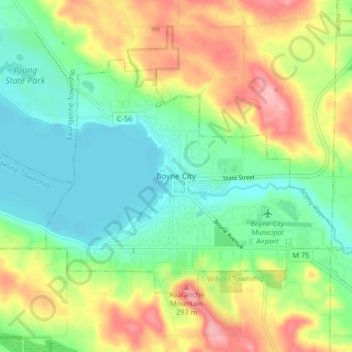
Nom : Carte topographique Boyne City, altitude, relief.
Altitude moyenne : 222 m
Altitude minimum : 170 m
Altitude maximum : 309 m
Autres cartes topographiques
Cliquez sur une carte pour visualiser sa topographie, son altitude et son relief.
Boyne Mountain
United States > Michigan > Charlevoix County
Boyne Mountain, Boyne Valley Township, Charlevoix County, Michigan, United States
Altitude moyenne : 263 m
Boyne Falls
United States > Michigan > Charlevoix County
Boyne Falls, Boyne Valley Township, Charlevoix County, Michigan, United States
Altitude moyenne : 231 m
Hudson Township
United States > Michigan > Charlevoix County
Hudson Township, Charlevoix County, Michigan, 49713, United States
Altitude moyenne : 361 m
Melrose Township
United States > Michigan > Charlevoix County
Melrose Township, Charlevoix County, Michigan, United States
Altitude moyenne : 238 m