
Carte topographique Lenox
Carte interactive
Cliquez sur la carte pour afficher l’altitude.
À propos de cette carte
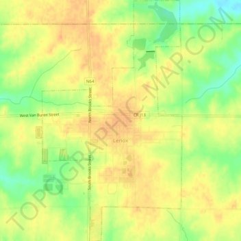
Nom : Carte topographique Lenox, altitude, relief.
Lieu : Lenox, Taylor County, Iowa, 50851, United States (40.86569 -94.57502 40.90301 -94.54627)
Altitude moyenne : 390 m
Altitude minimum : 367 m
Altitude maximum : 402 m
Autres cartes topographiques
Cliquez sur une carte pour visualiser sa topographie, son altitude et son relief.
Lenox
United States > Iowa > Taylor County > Lenox
Lenox, Taylor County, Iowa, 50851, United States
Altitude moyenne : 389 m
Sharpsburg
United States > Iowa > Taylor County > Sharpsburg
Sharpsburg, Taylor County, Iowa, United States
Altitude moyenne : 387 m