
Carte topographique Salento
Carte interactive
Cliquez sur la carte pour afficher l’altitude.
À propos de cette carte
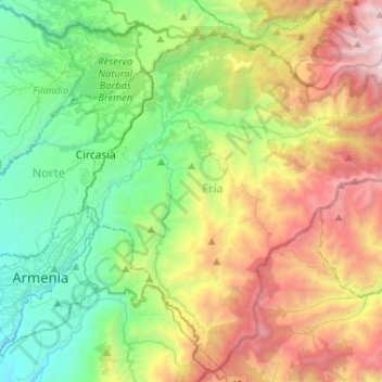
Nom : Carte topographique Salento, altitude, relief.
Lieu : Salento, Fría, Quindío, RAP Eje Cafetero, Colombia (4.47274 -75.64283 4.71653 -75.38269)
Altitude moyenne : 2’335 m
Altitude minimum : 1’288 m
Altitude maximum : 4’288 m
The town of Salento itself lies on a plateau above the Quindío river valley. The section of the river valley from Salento to the head of the river is known as the Cocora valley. The town is located at an average altitude of 1895 meters above sea level, with steep drops to the valley floor at its northern and western perimeters.
Autres cartes topographiques
Cliquez sur une carte pour visualiser sa topographie, son altitude et son relief.
Valle del Cocora - Palma de Cera
Valle del Cocora - Palma de Cera, Cocora, Salento, Fría, Quindío, RAP Eje Cafetero, Colombia
Altitude moyenne : 2’623 m
Las Alamos
Las Alamos, Génova, Cordillerana, Quindío, RAP Eje Cafetero, 632087, Colombia
Altitude moyenne : 1’790 m
Perímetro Urbano Armenia
Perímetro Urbano Armenia, Armenia, Capital, Quindío, RAP Eje Cafetero, Colombia
Altitude moyenne : 1’481 m