
Carte topographique Mentone
Carte interactive
Cliquez sur la carte pour afficher l’altitude.
À propos de cette carte
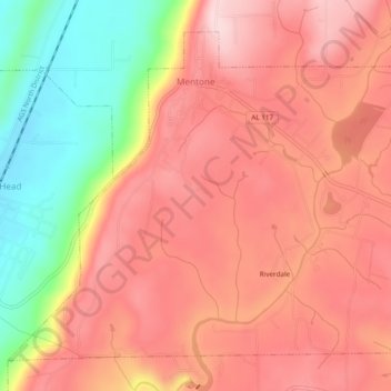
Nom : Carte topographique Mentone, altitude, relief.
Lieu : Mentone, DeKalb County, Alabama, 35984, United States (34.55130 -85.61363 34.58458 -85.56558)
Altitude moyenne : 471 m
Altitude minimum : 307 m
Altitude maximum : 566 m
Mentone is located in eastern DeKalb County at 34°34′20″N 85°34′49″W / 34.57222°N 85.58028°W / 34.57222; -85.58028 (34.572360, -85.580283). It is bordered to the west by the town of Valley Head. The center of town is located on the crest of Lookout Mountain at an elevation of 1,736 feet (529 m). The western border of the town, with Valley Head, follows the western slopes of the mountain. Extending south from the town center is the mountain's ridgecrest that rises to an elevation of 1,785 feet (544 m) within the town limits. The West Fork of the Little River crosses the eastern portion of the town at an elevation less than 100 feet (30 m) below the ridgecrest.
Autres cartes topographiques
Cliquez sur une carte pour visualiser sa topographie, son altitude et son relief.
Fort Payne
United States > Alabama > DeKalb County
Fort Payne, DeKalb County, Alabama, 35967, United States
Altitude moyenne : 369 m
Henagar
United States > Alabama > DeKalb County
Henagar, DeKalb County, Alabama, 35978, United States
Altitude moyenne : 436 m
Grove Oak
United States > Alabama > DeKalb County
Grove Oak, DeKalb County, Alabama, 35975, United States
Altitude moyenne : 344 m
Hammondville
United States > Alabama > DeKalb County
Hammondville, DeKalb County, Alabama, United States
Altitude moyenne : 362 m
Shiloh
United States > Alabama > DeKalb County
Shiloh, DeKalb County, Alabama, United States
Altitude moyenne : 376 m
Lakeview
United States > Alabama > DeKalb County
Lakeview, DeKalb County, Alabama, United States
Altitude moyenne : 344 m
Valley Head
United States > Alabama > DeKalb County
Valley Head, DeKalb County, Alabama, United States
Altitude moyenne : 410 m
Collinsville
United States > Alabama > DeKalb County
Collinsville, DeKalb County, Alabama, 35961, United States
Altitude moyenne : 285 m
Rainsville
United States > Alabama > DeKalb County
Rainsville, DeKalb County, Alabama, 35986, United States
Altitude moyenne : 380 m
Crossville
United States > Alabama > DeKalb County
Crossville, DeKalb County, Alabama, United States
Altitude moyenne : 337 m
Powell
United States > Alabama > DeKalb County
Powell, DeKalb County, Alabama, United States
Altitude moyenne : 380 m
Mentone
United States > Alabama > DeKalb County
Mentone, DeKalb County, Alabama, 35984, United States
Altitude moyenne : 470 m
Geraldine
United States > Alabama > DeKalb County
Geraldine, DeKalb County, Alabama, 35974, United States
Altitude moyenne : 349 m
Fyffe
United States > Alabama > DeKalb County
Fyffe, DeKalb County, Alabama, 35971, United States
Altitude moyenne : 376 m
Pine Ridge
United States > Alabama > DeKalb County
Pine Ridge, DeKalb County, Alabama, United States
Altitude moyenne : 312 m
Desoto State Park
United States > Alabama > DeKalb County > Fort Payne
Desoto State Park, Fort Payne, DeKalb County, Alabama, United States
Altitude moyenne : 454 m
Minvale
United States > Alabama > DeKalb County > Fort Payne > Minvale
Minvale, Fort Payne, DeKalb County, Alabama, 35967, United States
Altitude moyenne : 322 m
Little River Canyon National Preserve
United States > Alabama > DeKalb County > Fort Payne
Little River Canyon National Preserve, Fort Payne, DeKalb County, Alabama, United States
Altitude moyenne : 328 m
Collinsville
United States > Alabama > DeKalb County > Collinsville
Collinsville, DeKalb County, Alabama, 35961, United States
Altitude moyenne : 285 m
Ider
United States > Alabama > DeKalb County
Ider, DeKalb County, Alabama, United States
Altitude moyenne : 467 m
Fort Payne
United States > Alabama > DeKalb County > Fort Payne
Fort Payne, DeKalb County, Alabama, 35967, United States
Altitude moyenne : 350 m
Red Hill
United States > Alabama > DeKalb County
Red Hill, DeKalb County, Alabama, United States
Altitude moyenne : 255 m
Sylvania
United States > Alabama > DeKalb County
Sylvania, DeKalb County, Alabama, 35988, United States
Altitude moyenne : 405 m