
Carte topographique Stege
Carte interactive
Cliquez sur la carte pour afficher l’altitude.
À propos de cette carte
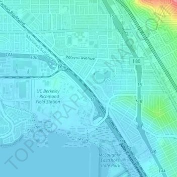
Nom : Carte topographique Stege, altitude, relief.
Altitude moyenne : 10 m
Altitude minimum : -4 m
Altitude maximum : 95 m
Stege, founded in 1876, was an unincorporated community in western Contra Costa County, California, United States. The town has now been annexed and absorbed by the cities of Richmond and El Cerrito, California. It was located on the Southern Pacific Railroad 1.5 miles (2.4 km) south-southeast of downtown Richmond, at an elevation of 23 feet (7 m). The site is now located in the area known as the Richmond Annex, at coordinates: 37°55′00″N 122°19′38″W / 37.91667°N 122.32722°W / 37.91667; -122.32722.
Autres cartes topographiques
Cliquez sur une carte pour visualiser sa topographie, son altitude et son relief.
Giant
United States > California > Contra Costa County > Richmond
Giant, Richmond, Contra Costa County, California, 94604, United States
Altitude moyenne : 12 m
Red Rock
United States > California > Contra Costa County > Richmond
Red Rock, Richmond, Contra Costa County, California, United States
Altitude moyenne : 0 m
El Sobrante
United States > California > Contra Costa County > Richmond
El Sobrante, Richmond, Contra Costa County, CAL Fire Northern Region, California, 94803, United States
Altitude moyenne : 79 m
Richmond
United States > California > Contra Costa County > Richmond
Richmond, Contra Costa County, California, 94804, United States
Altitude moyenne : 63 m