
Carte topographique Garden City
Carte interactive
Cliquez sur la carte pour afficher l’altitude.
À propos de cette carte
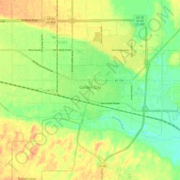
Nom : Carte topographique Garden City, altitude, relief.
Lieu : Garden City, Finney County, Kansas, 67846, United States (37.93694 -100.90168 38.00357 -100.79251)
Altitude moyenne : 870 m
Altitude minimum : 852 m
Altitude maximum : 886 m
Garden City is at 37°58′31″N 100°51′51″W / 37.97528°N 100.86417°W / 37.97528; -100.86417 at an elevation of 2,838 feet (865 m). The city lies on the north side of the Arkansas River in the High Plains region of the Great Plains. It is located in southwestern Kansas at the intersection of U.S. Route 50 and U.S. Route 83, Garden City is 192 miles (309 km) west-northwest of Wichita, 204 miles (328 km) north-northeast of Amarillo, and 255 miles (410 km) southeast of Denver. According to the United States Census Bureau, the city has a total area of 8.82 square miles (22.84 km2), all land. It is the most remote city in America with population over 25,000.
Autres cartes topographiques
Cliquez sur une carte pour visualiser sa topographie, son altitude et son relief.
Plymell
United States > Kansas > Finney County
Plymell, Finney County, Kansas, United States
Altitude moyenne : 878 m
Holcomb
United States > Kansas > Finney County
Holcomb, Finney County, Kansas, United States
Altitude moyenne : 879 m
Pierceville
United States > Kansas > Finney County
Pierceville, Finney County, Kansas, 67868, United States
Altitude moyenne : 848 m
Ravanna
United States > Kansas > Finney County > Ravanna
Ravanna, Finney County, Kansas, United States
Altitude moyenne : 782 m
Garden City
United States > Kansas > Finney County > Garden City > Garden City
Garden City, Finney County, Kansas, 67846-5440, United States
Altitude moyenne : 882 m