
Carte topographique Darcha
Carte interactive
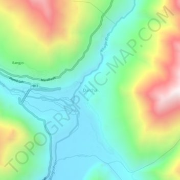
Cliquez sur la carte pour afficher l’altitude.
À propos de cette carte
Nom : Carte topographique Darcha, altitude, relief.
Altitude moyenne : 3’702 m
Altitude minimum : 3’284 m
Altitude maximum : 4’563 m
Darcha also known as Dartse (elevation 3,360 m or 11,020 ft) is a pair of villages (Darcha Sumdo and Darach Dangma) on the Bhaga River in the Lahaul sub-division in the Lahaul and Spiti district in the Indian state of Himachal Pradesh. It is the northernmost permanent settlement in Himachal Pradesh along the Manali-Leh Highway. With the opening of the Atal Tunnel, Darcha is likely to see a large influx of tourists as it is now connected to Manali throughout the year. The Nimmu–Padam–Darcha road which is being constructed, will improve connectivity of Kargil, Zanskar and Leh District of Ladakh to Darcha.
Autres cartes topographiques
Cliquez sur une carte pour visualiser sa topographie, son altitude et son relief.
Chandratal Lake
India > Himachal Pradesh > Lahul
Chandratal Lake, Lahul, Lahaul and Spiti District, Himachal Pradesh, India
Altitude moyenne : 4’403 m
Sarchu
India > Himachal Pradesh > Lahul
Sarchu, Lahul, Lahul and Spiti, Himachal Pradesh, India
Altitude moyenne : 5’408 m
Teling
India > Himachal Pradesh > Lahul
Teling, Lahul, Lahul and Spiti, Himachal Pradesh, India
Altitude moyenne : 3’527 m
Koksar
India > Himachal Pradesh > Lahul
Koksar, Lahul, Lahul and Spiti, Himachal Pradesh, India
Altitude moyenne : 3’634 m
Sissu
India > Himachal Pradesh > Lahul > Sissu
Sissu, Lahul, Lahul and Spiti, Himachal Pradesh, India
Altitude moyenne : 4’343 m
Chikka
India > Himachal Pradesh > Lahul
Chikka, Lahul, Lahaul and Spiti District, Himachal Pradesh, India
Altitude moyenne : 4’094 m
Rohtang Pass
India > Himachal Pradesh > Lahul
Rohtang Pass, Lahul, Lahul and Spiti, Himachal Pradesh, India
Altitude moyenne : 4’042 m
Sissu
India > Himachal Pradesh > Lahul
Sissu, Lahul, Lahaul and Spiti District, Himachal Pradesh, India
Altitude moyenne : 3’404 m