
Carte topographique Valle del Sol
Carte interactive
Cliquez sur la carte pour afficher l’altitude.
À propos de cette carte
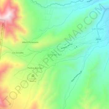
Nom : Carte topographique Valle del Sol, altitude, relief.
Altitude moyenne : 2’069 m
Altitude minimum : 1’815 m
Altitude maximum : 2’545 m
Autres cartes topographiques
Cliquez sur une carte pour visualiser sa topographie, son altitude et son relief.
Parque Provincial Cordón Del Plata
Argentina > Mendoza > Valle del Sol > Villa El Portezuelo
Parque Provincial Cordón Del Plata, Francisco Guiñazú, Villa El Portezuelo, Valle del Sol, Distrito Potrerillos, Departamento Luján de Cuyo, Mendoza, Argentina
Altitude moyenne : 3’023 m