Géolocaliser

Carte topographique Welbourn

Cliquez sur la carte pour afficher l’altitude.

À propos de cette carte

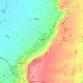
Nom : Carte topographique Welbourn, altitude, relief.

Lieu : Welbourn, North Kesteven, Lincolnshire, East Midlands, England, United Kingdom (53.05787 -0.61414 53.09044 -0.51841)

Altitude moyenne : 50 m

Altitude minimum : 7 m

Altitude maximum : 109 m

Autres cartes topographiques

Cliquez sur une carte pour visualiser sa topographie, son altitude et son relief.

Eagle

United Kingdom > England > Lincolnshire > North Kesteven

Altitude moyenne : 17 m

Howell

United Kingdom > England > Lincolnshire > North Kesteven > Ewerby

Altitude moyenne : 9 m

Whisby

United Kingdom > England > Lincolnshire > North Kesteven

Altitude moyenne : 21 m

Cranwell

United Kingdom > England > Lincolnshire > North Kesteven

Altitude moyenne : 46 m

Aswarby

United Kingdom > England > Lincolnshire > North Kesteven

Altitude moyenne : 21 m

Quarrington

United Kingdom > England > Lincolnshire > North Kesteven

According to the Köppen classification, the British Isles experience a maritime climate characterised by relatively cool summers and mild winters. Lincolnshire's position on the east of the Isles allows for a sunnier and warmer climate relative to the national average, and it is one of the driest counties in…

Altitude moyenne : 21 m

Nocton

United Kingdom > England > Lincolnshire > North Kesteven

Altitude moyenne : 21 m

Branston

United Kingdom > England > Lincolnshire > North Kesteven

Altitude moyenne : 40 m

Welbourn

United Kingdom > England > Lincolnshire > North Kesteven

Altitude moyenne : 50 m

Kelby

United Kingdom > England > Lincolnshire > North Kesteven

Altitude moyenne : 68 m

Ewerby

United Kingdom > England > Lincolnshire > North Kesteven

Altitude moyenne : 11 m

Greylees

United Kingdom > England > Lincolnshire > North Kesteven

Altitude moyenne : 29 m

Coleby

United Kingdom > England > Lincolnshire > North Kesteven

Altitude moyenne : 50 m

Spanby

United Kingdom > England > Lincolnshire > North Kesteven

Altitude moyenne : 18 m

Dunston

United Kingdom > England > Lincolnshire > North Kesteven

Altitude moyenne : 21 m

Anwick

United Kingdom > England > Lincolnshire > North Kesteven

Altitude moyenne : 7 m

Sutton

United Kingdom > England > Lincolnshire > North Kesteven > Sutton

Altitude moyenne : 17 m

Martin

United Kingdom > England > Lincolnshire > North Kesteven

Altitude moyenne : 10 m

Walcott

United Kingdom > England > Lincolnshire > North Kesteven

Altitude moyenne : 7 m

Équipez-vous pour votre prochaine aventure :

🎒Sacs à dos de randonnée - Sacs ergonomiques pour randonnées à la journée ou sur plusieurs jours
📱Supports téléphone vélo - Fixation sécurisée pour navigation GPS
🛌Sac de couchage thermique - Conçu pour résister aux nuits fraîches des sommets helvétiques
🗺️Cartes topographiques papier - Cartes détaillées pour randonnée, orientation et lecture du relief
🗺️Atlas géographiques - Références cartographiques

En tant que Partenaire Amazon, ce site perçoit une commission sur les achats éligibles sans surcoût pour vous.