
Faire un don
Équipez-vous pour votre prochaine aventure :
En tant que Partenaire Amazon, ce site perçoit une commission sur les achats éligibles sans surcoût pour vous.
Carte topographique Donges Bay
Cliquez sur la carte pour afficher l’altitude.
Faire un don
Équipez-vous pour votre prochaine aventure :
En tant que Partenaire Amazon, ce site perçoit une commission sur les achats éligibles sans surcoût pour vous.
À propos de cette carte
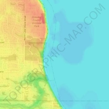
Nom : Carte topographique Donges Bay, altitude, relief.
Lieu : Donges Bay, Ozaukee County, Wisconsin, 53092, United States (43.20357 -87.89430 43.20367 -87.89420)
Altitude moyenne : 190 m
Altitude minimum : 171 m
Altitude maximum : 225 m
Faire un don
Équipez-vous pour votre prochaine aventure :
En tant que Partenaire Amazon, ce site perçoit une commission sur les achats éligibles sans surcoût pour vous.
Autres cartes topographiques
Cliquez sur une carte pour visualiser sa topographie, son altitude et son relief.
Port Washington
United States > Wisconsin > Ozaukee County
The city is located on the western shore of Lake Michigan. In northern and southern parts of the city, the coastline is characterized by clay bluffs ranging from 80 feet (24 meters) to 130 feet (40 meters) in height with deep ravines where streams flow into the lake. Clay bluffs are a geological formation…
Altitude moyenne : 205 m
Faire un don
Équipez-vous pour votre prochaine aventure :
En tant que Partenaire Amazon, ce site perçoit une commission sur les achats éligibles sans surcoût pour vous.
Faire un don
Équipez-vous pour votre prochaine aventure :
En tant que Partenaire Amazon, ce site perçoit une commission sur les achats éligibles sans surcoût pour vous.
Port Washington
United States > Wisconsin > Ozaukee County
The city is located on the western shore of Lake Michigan. In northern and southern parts of the city, the coastline is characterized by clay bluffs ranging from 80 feet (24 meters) to 130 feet (40 meters) in height with deep ravines where streams flow into the lake. Clay bluffs are a geological formation…
Altitude moyenne : 201 m
Faire un don
Équipez-vous pour votre prochaine aventure :
En tant que Partenaire Amazon, ce site perçoit une commission sur les achats éligibles sans surcoût pour vous.