
Carte topographique Ekurhuleni Ward 31
Carte interactive
Cliquez sur la carte pour afficher l’altitude.
À propos de cette carte
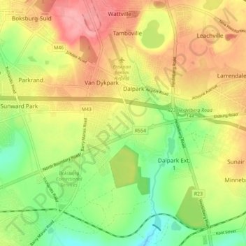
Nom : Carte topographique Ekurhuleni Ward 31, altitude, relief.
Altitude moyenne : 1’617 m
Altitude minimum : 1’566 m
Altitude maximum : 1’667 m
Autres cartes topographiques
Cliquez sur une carte pour visualiser sa topographie, son altitude et son relief.
Braamfontein Spruit
RSA > Gauteng > Johannesburg
Braamfontein Spruit, Johannesburg, City of Johannesburg Metropolitan Municipality, Gauteng, 2001, RSA
Altitude moyenne : 1’672 m
Roodeplaat Dam
Roodeplaat Dam, Dwars Road, Tshwane Ward 99, Pretoria, City of Tshwane Metropolitan Municipality, Gauteng, 0035, RSA
Altitude moyenne : 1’240 m
Roodepoort
RSA > Gauteng > Roodepoort
Roodepoort, City of Johannesburg Metropolitan Municipality, Gauteng, 1734, RSA
Altitude moyenne : 1’612 m
Tshwane Ward 85
Tshwane Ward 85, Pretoria, City of Tshwane Metropolitan Municipality, Gauteng, RSA
Altitude moyenne : 1’391 m
Johannesburg Ward 97
RSA > Gauteng > Roodepoort
Johannesburg Ward 97, Roodepoort, City of Johannesburg Metropolitan Municipality, Gauteng, 2040, RSA
Altitude moyenne : 1’582 m
Ekurhuleni Ward 75
Ekurhuleni Ward 75, Springs, City of Ekurhuleni Metropolitan Municipality, Gauteng, RSA
Altitude moyenne : 1’607 m
Tshwane Ward 77
Tshwane Ward 77, Pretoria, City of Tshwane Metropolitan Municipality, Gauteng, RSA
Altitude moyenne : 1’502 m
Johannesburg Ward 101
Johannesburg Ward 101, Randburg, City of Johannesburg Metropolitan Municipality, Gauteng, 2188, RSA
Altitude moyenne : 1’523 m
Ekurhuleni Ward 28
Ekurhuleni Ward 28, Benoni, City of Ekurhuleni Metropolitan Municipality, Gauteng, RSA
Altitude moyenne : 1’651 m
Johannesburg Ward 64
RSA > Gauteng > Johannesburg
Johannesburg Ward 64, Johannesburg, City of Johannesburg Metropolitan Municipality, Gauteng, 2001, RSA
Altitude moyenne : 1’758 m
Johannesburg Ward 74
Johannesburg Ward 74, Sandton, City of Johannesburg Metropolitan Municipality, Gauteng, RSA
Altitude moyenne : 1’638 m
Tshwane Ward 46
Tshwane Ward 46, Pretoria, City of Tshwane Metropolitan Municipality, Gauteng, RSA
Altitude moyenne : 1’396 m