
Carte topographique Clayton
Carte interactive
Cliquez sur la carte pour afficher l’altitude.
À propos de cette carte
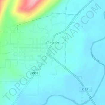
Nom : Carte topographique Clayton, altitude, relief.
Lieu : Clayton, Pushmataha County, Oklahoma, 74536, United States (34.57541 -95.37129 34.59851 -95.34265)
Altitude moyenne : 188 m
Altitude minimum : 162 m
Altitude maximum : 330 m
Clayton, located in the Kiamichi River valley, is framed on its west by Flagpole Mountain (1,562 ft.) and to its east by unnamed mountains topping 1,600 feet in elevation. Within a few miles of Clayton is scenic McKinley Rocks, a collection of massive boulders strewn across a mountain top. South of Clayton is Clayton Lake State Park—which is surrounded by a pine tree forest—and northwest of town is Sardis Lake, a U.S. Army Corps of Engineers dam which impounds the water of Jack's Fork Creek. The Pushmataha Wildlife Refuge is also nearby, featuring scenic views from its mountain summit.
Autres cartes topographiques
Cliquez sur une carte pour visualiser sa topographie, son altitude et son relief.
Finley
United States > Oklahoma > Pushmataha County
Finley, Pushmataha County, Oklahoma, 74543, United States
Altitude moyenne : 155 m
Nashoba
United States > Oklahoma > Pushmataha County
Nashoba, Pushmataha County, Oklahoma, 74558, United States
Altitude moyenne : 233 m
Albion
United States > Oklahoma > Pushmataha County > Albion
Albion, Pushmataha County, Oklahoma, 74524, United States
Altitude moyenne : 207 m
Antlers
United States > Oklahoma > Pushmataha County
Antlers, Pushmataha County, Oklahoma, United States
Altitude moyenne : 154 m