
Carte topographique Bandar Abbas
Carte interactive
Cliquez sur la carte pour afficher l’altitude.
À propos de cette carte
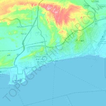
Nom : Carte topographique Bandar Abbas, altitude, relief.
Altitude moyenne : 27 m
Altitude minimum : -5 m
Altitude maximum : 187 m
Bandar Abbas is situated on flat ground with an average altitude of 9 metres (30 ft) above sea level. The nearest elevated areas are Mt. Geno, 17 kilometres (11 mi) to the north, and Mt. Pooladi, 16 kilometres (9.9 mi) to the northwest of the city. The closest river to Bandar Abbas is the River Shoor, which rises on Mt. Geno and flows into the Persian Gulf, 10 kilometres (6.2 mi) east of the city. South of the city is the island of Qeshm.