
Carte topographique Ashland
Carte interactive
Cliquez sur la carte pour afficher l’altitude.
À propos de cette carte
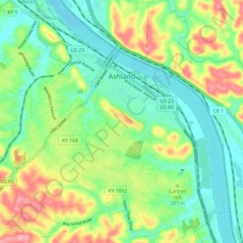
Nom : Carte topographique Ashland, altitude, relief.
Lieu : Ashland, Boyd County, Kentucky, 41101, United States (38.43440 -82.68193 38.49846 -82.60629)
Altitude moyenne : 196 m
Altitude minimum : 155 m
Altitude maximum : 270 m
Autres cartes topographiques
Cliquez sur une carte pour visualiser sa topographie, son altitude et son relief.
Ironville
United States > Kentucky > Boyd County
Ironville, Boyd County, Kentucky, 41102, United States
Altitude moyenne : 214 m
Westwood
United States > Kentucky > Boyd County > Fairview
Westwood, Fairview, Boyd County, Kentucky, United States
Altitude moyenne : 192 m
Cannonsburg
United States > Kentucky > Boyd County
Cannonsburg, Boyd County, Kentucky, 41105, United States
Altitude moyenne : 217 m
Boltsfork
United States > Kentucky > Boyd County > Boltsfork
Boltsfork, Boyd County, Kentucky, United States
Altitude moyenne : 241 m
Catlettsburg
United States > Kentucky > Boyd County
Catlettsburg, Boyd County, Kentucky, United States
Altitude moyenne : 190 m
Rush
United States > Kentucky > Boyd County
Rush, Boyd County, Kentucky, 41168, United States
Altitude moyenne : 244 m