
Carte topographique Dover
Carte interactive
Cliquez sur la carte pour afficher l’altitude.
À propos de cette carte
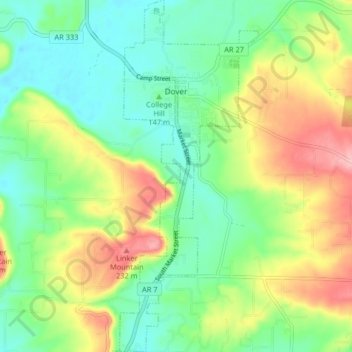
Nom : Carte topographique Dover, altitude, relief.
Lieu : Dover, Pope County, Arkansas, 72837, United States (35.35115 -93.12742 35.41773 -93.09518)
Altitude moyenne : 164 m
Altitude minimum : 113 m
Altitude maximum : 252 m
The mild hills historically supported oak-hickory forest or oak-hickory-pine forest. Elevation changes and soil types make the Arkansas Valley Hills largely unsuitable for row agriculture. Instead, forest has been cleared for pastureland, poultry farming or ranching. Logging remains an important land use where elevation or soil makes livestock farming unsuitable. Many of the smaller streams and watercourses are completely dry in summer.
Autres cartes topographiques
Cliquez sur une carte pour visualiser sa topographie, son altitude et son relief.
Smyrna
United States > Arkansas > Pope County
Smyrna, Pope County, Arkansas, United States
Altitude moyenne : 402 m
Russellville
United States > Arkansas > Pope County
Russellville, Pope County, Arkansas, United States
Altitude moyenne : 133 m
Dover
United States > Arkansas > Pope County > Dover > Dover
Dover, Pope County, Arkansas, 72837, United States
Altitude moyenne : 150 m
Moreland
United States > Arkansas > Pope County > Moreland
Moreland, Pope County, Arkansas, 72802:72837, United States
Altitude moyenne : 236 m
Worthen
United States > Arkansas > Pope County > Pottsville
Worthen, Pottsville, Pope County, Arkansas, 72858, United States
Altitude moyenne : 143 m