
Carte topographique Chatham
Cliquez sur la carte pour afficher l’altitude.
À propos de cette carte
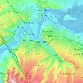
Nom : Carte topographique Chatham, altitude, relief.
Lieu : Chatham, Medway, England, ME4 4AP, United Kingdom (51.34192 0.48656 51.42192 0.56656)
Altitude moyenne : 49 m
Altitude minimum : -2 m
Altitude maximum : 164 m
Autres cartes topographiques
Cliquez sur une carte pour visualiser sa topographie, son altitude et son relief.
Rainham Creek
United Kingdom > England > Medway > Gillingham > Lower Rainham > Motney Hill
Altitude moyenne : 4 m