
Carte topographique Kaza
Carte interactive
Cliquez sur la carte pour afficher l’altitude.
À propos de cette carte
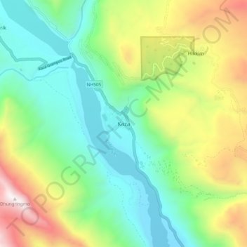
Nom : Carte topographique Kaza, altitude, relief.
Lieu : Kaza, Spiti, Lahul and Spiti, Himachal Pradesh, India (32.18438 78.03226 32.26438 78.11226)
Altitude moyenne : 4’161 m
Altitude minimum : 3’532 m
Altitude maximum : 5’417 m
Kaza, also spelled Kaze, Karze, Karzey, is a town and the subdivisional headquarters of the remote Spiti Valley in the western Himalayas in the Lahaul and Spiti district of the northern Indian state of Himachal Pradesh. Spiti is a high altitude or cold desert having close similarities to the neighbouring Tibet and Ladakh regions in terms of terrain, climate and the Buddhist culture. Kaza, situated along the Spiti River at an elevation of 3,650 metres (11,980 ft) above mean sea level, is the largest township and commercial center of the Spiti valley.
Autres cartes topographiques
Cliquez sur une carte pour visualiser sa topographie, son altitude et son relief.
Hikkim
India > Himachal Pradesh > Spiti > Hikkim
Hikkim, Spiti, Lahul and Spiti, Himachal Pradesh, India
Altitude moyenne : 4’511 m
Tabo
India > Himachal Pradesh > Spiti
Tabo, Spiti, Lahul and Spiti, Himachal Pradesh, India
Altitude moyenne : 4’069 m