
Carte topographique دهستان طرود
Carte interactive
Cliquez sur la carte pour afficher l’altitude.
À propos de cette carte
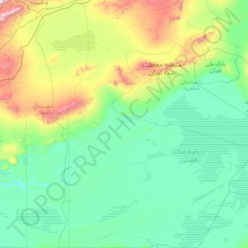
Nom : Carte topographique دهستان طرود, altitude, relief.
Lieu : دهستان طرود, بخش مرکزی, Shahrud County, Semnan Province, Iran (34.23803 54.59475 36.27388 55.75397)
Altitude moyenne : 941 m
Altitude minimum : 671 m
Altitude maximum : 2’770 m
Autres cartes topographiques
Cliquez sur une carte pour visualiser sa topographie, son altitude et son relief.
خرقان
Iran > Semnan Province > Shahrud County > دهستان خرقان
خرقان, دهستان خرقان, بخش بسطام, Shahrud County, Semnan Province, Iran
Altitude moyenne : 1’514 m
Bastam
Iran > Semnan Province > Shahrud County > دهستان خرقان
Bastam, دهستان خرقان, بخش بسطام, Shahrud County, Semnan Province, Iran
Altitude moyenne : 1’434 m
Shahrud
Iran > Semnan Province > Shahrud County
Shahrud, بخش مرکزی, Shahrud County, Semnan Province, Iran
Altitude moyenne : 1’375 m
Shahrud
Iran > Semnan Province > Shahrud County > Shahrud
Shahrud, بخش مرکزی, Shahrud County, Semnan Province, Iran
Altitude moyenne : 1’510 m