
Carte topographique Sengscheid
Carte interactive
Cliquez sur la carte pour afficher l’altitude.
À propos de cette carte
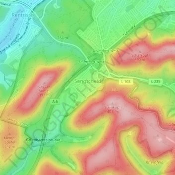
Nom : Carte topographique Sengscheid, altitude, relief.
Lieu : Sengscheid, St. Ingbert, Saarpfalz-Kreis, Saarland, Deutschland (49.24563 7.07944 49.26383 7.10821)
Altitude moyenne : 303 m
Altitude minimum : 206 m
Altitude maximum : 401 m
Autres cartes topographiques
Cliquez sur une carte pour visualiser sa topographie, son altitude et son relief.
St. Ingbert-Mitte
Deutschland > Saarland > St. Ingbert
St. Ingbert-Mitte, St. Ingbert, Saarpfalz-Kreis, Saarland, 66386, Deutschland
Altitude moyenne : 292 m