
Carte topographique Lützen
Carte interactive
Cliquez sur la carte pour afficher l’altitude.
À propos de cette carte
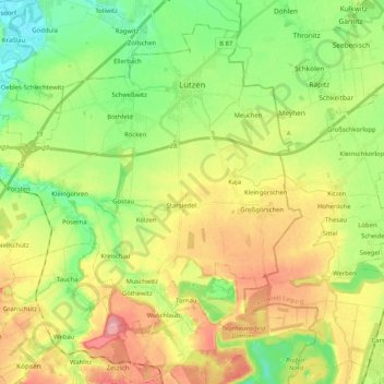
Nom : Carte topographique Lützen, altitude, relief.
Lieu : Lützen, Burgenlandkreis, Saxony-Anhalt, 06686, Germany (51.16610 11.99926 51.27874 12.20480)
Altitude moyenne : 135 m
Altitude minimum : 89 m
Altitude maximum : 197 m
Autres cartes topographiques
Cliquez sur une carte pour visualiser sa topographie, son altitude et son relief.
Großjena
Germany > Saxony-Anhalt > Burgenlandkreis > Naumburg (Saale)
Großjena, Naumburg (Saale), Burgenlandkreis, Saxony-Anhalt, 06632, Germany
Altitude moyenne : 142 m