
Carte topographique Albertville
Carte interactive
Cliquez sur la carte pour afficher l’altitude.
À propos de cette carte
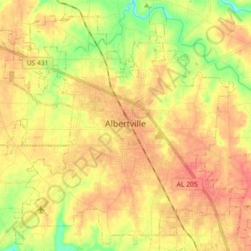
Nom : Carte topographique Albertville, altitude, relief.
Lieu : Albertville, Marshall County, Alabama, 35950, United States (34.21637 -86.27448 34.31681 -86.14596)
Altitude moyenne : 309 m
Altitude minimum : 254 m
Altitude maximum : 356 m
The city sits at an elevation of 1,060 feet (320 m) atop Sand Mountain, a plateau that in this area is about 15 miles (24 km) wide. The Tennessee Valley Divide passes through the southern part of the city. The majority of the city drains north to Short Creek, a tributary of the Tennessee River, while the southern part drains to Slab Creek, a west-flowing tributary of the Locust Fork of the Black Warrior River. The current slogan of Albertville is "The Heart of Sand Mountain", which can be seen on the welcome sign coming into the city.
Autres cartes topographiques
Cliquez sur une carte pour visualiser sa topographie, son altitude et son relief.
Grassy
United States > Alabama > Marshall County
Grassy, Marshall County, Alabama, United States
Altitude moyenne : 309 m
Arab
United States > Alabama > Marshall County
Arab, Marshall County, Alabama, 35016, United States
Altitude moyenne : 314 m