
Carte topographique Lead
Carte interactive
Cliquez sur la carte pour afficher l’altitude.
À propos de cette carte
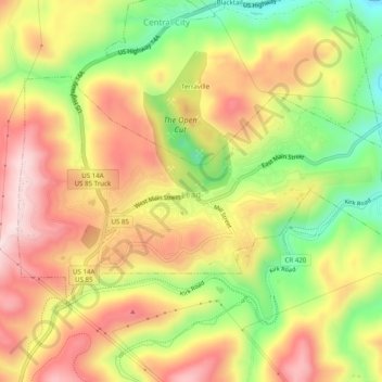
Nom : Carte topographique Lead, altitude, relief.
Lieu : Lead, Lawrence County, South Dakota, United States (44.34184 -103.78764 44.36313 -103.73826)
Altitude moyenne : 1’605 m
Altitude minimum : 1’417 m
Altitude maximum : 1’764 m
Its high elevation in the Black Hills makes Lead one of the wettest places in South Dakota and among the snowiest places in the contiguous United States with a mean snowfall of 183.9 inches or 4.67 metres. During the cold and snowy winter of 1993–94, a whopping 364.7 inches (9.26 m) of snow fell and three years later snowfall totalled 324.0 inches (8.23 m). However, frequent chinook winds mean that most of the enormous snowfall melts during the winter: the highest snow cover on record is 73 inches (1.85 m) on March 1, 1998 – during a storm that totalled 114.6 inches or 2.91 metres of snow (water equivalent 4.12 inches or 104.6 millimetres) over six days ending March 2. Mean snow depth in January is only 7 inches or 0.18 metres and the median even less at 5 inches or 0.13 metres. 12.9 mornings can be expected to fall to or below 0 °F (−17.8 °C), with the average window for zero temperatures being December 7 to March 3; on the other hand during winter 12.8 afternoons can be expected to get to or above 50 °F or 10 °C. The coldest temperature has been −40 °F or −40 °C on February 8, 1936.
Autres cartes topographiques
Cliquez sur une carte pour visualiser sa topographie, son altitude et son relief.
Terry Peak
United States > South Dakota > Lawrence County
Terry Peak, Lawrence County, South Dakota, United States
Altitude moyenne : 1’940 m
Spearfish
United States > South Dakota > Lawrence County > Spearfish
Spearfish, Lawrence County, South Dakota, 57783, United States
Altitude moyenne : 1’291 m
Spearfish
United States > South Dakota > Lawrence County
Spearfish, Lawrence County, South Dakota, United States
Altitude moyenne : 1’171 m
Deadwood
United States > South Dakota > Lawrence County
Deadwood, Lawrence County, South Dakota, 57732, United States
Altitude moyenne : 1’511 m