
Carte topographique Leeds and the Thousand Islands
Carte interactive
Cliquez sur la carte pour afficher l’altitude.
À propos de cette carte
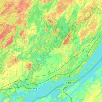
Nom : Carte topographique Leeds and the Thousand Islands, altitude, relief.
Altitude moyenne : 102 m
Altitude minimum : 72 m
Altitude maximum : 185 m
Autres cartes topographiques
Cliquez sur une carte pour visualiser sa topographie, son altitude et son relief.
Pittston
Canada > Ontario > Leeds and Grenville Counties > Edwardsburgh/Cardinal
Altitude moyenne : 82 m
Cockburn Island
Canada > Ontario > Leeds and Grenville Counties > Elizabethtown-Kitley
Altitude moyenne : 112 m
St. Helena Island
Canada > Ontario > Leeds and Grenville Counties > Front of Yonge
Altitude moyenne : 115 m
Waterton
Canada > Ontario > Leeds and Grenville Counties > Leeds and the Thousand Islands > Waterton
Altitude moyenne : 97 m
Seeleys Bay
Canada > Ontario > Leeds and Grenville Counties > Leeds and the Thousand Islands > Seeley's Bay
Altitude moyenne : 105 m