
Carte topographique Prunedale
Carte interactive
Cliquez sur la carte pour afficher l’altitude.
À propos de cette carte
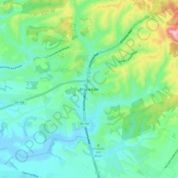
Nom : Carte topographique Prunedale, altitude, relief.
Altitude moyenne : 69 m
Altitude minimum : -8 m
Altitude maximum : 275 m
Prunedale is a census-designated place in Monterey County, California. Prunedale is located 8 miles (13 km) north of Salinas, at an elevation of 92 feet (28 m). The population was 17,560 residents at the time of the 2010 census, up from 16,432 at the 2000 census. Plum trees were grown in Prunedale in the early days of its founding but the trees died soon after due to poor irrigation and fertilizer.
Autres cartes topographiques
Cliquez sur une carte pour visualiser sa topographie, son altitude et son relief.
Prunedale
United States > California > Monterey County > Prunedale
Prunedale, Monterey County, California, United States
Altitude moyenne : 104 m