
Carte topographique Jena
Carte interactive
Cliquez sur la carte pour afficher l’altitude.
À propos de cette carte
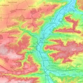
Nom : Carte topographique Jena, altitude, relief.
Lieu : Jena, Thuringia, Germany (50.85608 11.49896 50.98890 11.67299)
Altitude moyenne : 283 m
Altitude minimum : 131 m
Altitude maximum : 436 m
Jena is situated in a hilly landscape in eastern Thuringia at the Saale river, between the Harz mountains 85 km (53 mi) in the north, the Thuringian Forest/Thuringian Highland 50 km (31 mi) in the southwest and the Ore Mountains, 75 km (47 mi) in the southeast. The municipal terrain is hilly with rugged slopes at the valley's edges. The city centre is situated at 160 m of elevation, whereas the mountains on both sides of Saale valley rise up to 400 m. On the eastern side those are (from north to south): the Gleisberg near Kunitz, the Jenzig near Wogau, the Hausberg near Wenigenjena, the Kernberge near Wöllnitz, the Johannisberg near Lobeda and the Einsiedlerberg near Drackendorf. On the western side, there are the Jägersberg near Zwätzen, the Windknollen north of the city centre, the Tatzend west of the city centre, the Lichtenhainer Höhe near Lichtenhain, the Holzberg near Winzerla, the Jagdberg near Göschwitz and the Spitzenberg near Maua. The mountains belong to the geological formation of Ilm Saale Plate (Muschelkalk) and are relatively flat on their peaks but steep to the valleys in between. Due to its jagged surface, the municipal territory isn't very suitable for agriculture all the more since the most flat areas along the valley were built on during the 20th century. At the mountains is some forest of different leaf trees and pines.
Autres cartes topographiques
Cliquez sur une carte pour visualiser sa topographie, son altitude et son relief.
Hütscheroda
Germany > Thuringia > Wartburgkreis
Hütscheroda, Hörselberg-Hainich, Wartburgkreis, Thuringia, 99820, Germany
Altitude moyenne : 356 m
Königsee
Germany > Thuringia > Landkreis Saalfeld-Rudolstadt > Königsee
Königsee, Landkreis Saalfeld-Rudolstadt, Thuringia, Germany
Altitude moyenne : 434 m
Oberhasel
Germany > Thuringia > Uhlstädt-Kirchhasel > Oberhasel
Oberhasel, Uhlstädt-Kirchhasel, Kamsdorf, Landkreis Saalfeld-Rudolstadt, Thuringia, 07407, Germany
Altitude moyenne : 272 m
Großer Hermannstein
Großer Hermannstein, Hermannsteiner Weg, Ilmenau, Ilm-Kreis, Thuringia, 98693, Germany
Altitude moyenne : 661 m
Schloss
Germany > Thuringia > Bad Köstritz
Schloss, Julius-Sturm-Platz, Pohlitz, Bad Köstritz, Greiz, Thuringia, 07586, Germany
Altitude moyenne : 207 m
Silberthal
Germany > Thuringia > Silberthal
Silberthal, Bürgel, Saale-Holzland-Kreis, Thuringia, 07616, Germany
Altitude moyenne : 295 m
Eisenach
Germany > Thuringia > Wartburgkreis
Eisenach, Wartburgkreis, Thuringia, 99817, Germany
Altitude moyenne : 298 m