
Carte topographique Empire Township
Carte interactive
Cliquez sur la carte pour afficher l’altitude.
À propos de cette carte
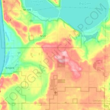
Nom : Carte topographique Empire Township, altitude, relief.
Lieu : Empire Township, Leelanau County, Michigan, United States (44.77831 -86.07863 44.86737 -85.93555)
Altitude moyenne : 244 m
Altitude minimum : 170 m
Altitude maximum : 342 m
Autres cartes topographiques
Cliquez sur une carte pour visualiser sa topographie, son altitude et son relief.
Suttons Bay
United States > Michigan > Leelanau County
Suttons Bay, Suttons Bay Township, Leelanau County, Michigan, United States
Altitude moyenne : 206 m
Northport
United States > Michigan > Leelanau County
Northport, Leelanau Township, Leelanau County, Michigan, 49670, United States
Altitude moyenne : 193 m
Cedar
United States > Michigan > Leelanau County
Cedar, Solon Township, Leelanau County, Michigan, 49621, United States
Altitude moyenne : 196 m
Leland
United States > Michigan > Leelanau County
Leland, Leland Township, Leelanau County, Michigan, 49654, United States
Altitude moyenne : 181 m
North Manitou Island
United States > Michigan > Leelanau County
North Manitou Island, Leland Township, Leelanau County, Michigan, United States
Altitude moyenne : 195 m
Maple City
United States > Michigan > Leelanau County > Maple City
Maple City, Kasson Township, Leelanau County, Michigan, 49664, United States
Altitude moyenne : 245 m
Empire
United States > Michigan > Leelanau County
Empire, Empire Township, Leelanau County, Michigan, United States
Altitude moyenne : 205 m
Glen Arbor
United States > Michigan > Leelanau County
Glen Arbor, Glen Arbor Township, Leelanau County, Michigan, 49636, United States
Altitude moyenne : 194 m
Sleeping Bear Dunes
United States > Michigan > Leelanau County
Sleeping Bear Dunes, Glen Arbor Township, Leelanau County, Michigan, United States
Altitude moyenne : 231 m