
Carte topographique Hemer
Carte interactive
Cliquez sur la carte pour afficher l’altitude.
À propos de cette carte
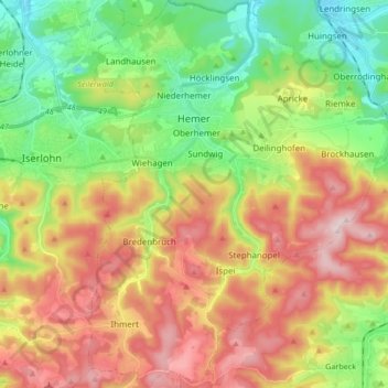
Nom : Carte topographique Hemer, altitude, relief.
Lieu : Hemer, Märkischer Kreis, North Rhine-Westphalia, 58675, Germany (51.31223 7.72022 51.41748 7.85342)
Altitude moyenne : 326 m
Altitude minimum : 152 m
Altitude maximum : 547 m
Hemer is located at the north end of the Sauerland near the Ruhr river. The highest elevation, at 546 metres (1,791 ft), is in the Balver Wald in the south of the city. The lowest elevation, at 160 metres (525 ft), is at the Edelburg in the northeast.