
Carte topographique Blanchard
Carte interactive
Cliquez sur la carte pour afficher l’altitude.
À propos de cette carte
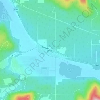
Nom : Carte topographique Blanchard, altitude, relief.
Lieu : Blanchard, Bonner County, Idaho, 83804, United States (47.99685 -117.00381 48.03685 -116.96381)
Altitude moyenne : 718 m
Altitude minimum : 682 m
Altitude maximum : 912 m
Autres cartes topographiques
Cliquez sur une carte pour visualiser sa topographie, son altitude et son relief.
Priest River
United States > Idaho > Bonner County
Priest River, Bonner County, Idaho, United States
Altitude moyenne : 742 m
Lake Pend Oreille
United States > Idaho > Bonner County
Lake Pend Oreille, Bonner County, Idaho, United States
Altitude moyenne : 941 m
Sandpoint
United States > Idaho > Bonner County
Sandpoint, Bonner County, Idaho, United States
Altitude moyenne : 658 m
East Hope
United States > Idaho > Bonner County > East Hope
East Hope, Bonner County, Idaho, United States
Altitude moyenne : 710 m
Clark Fork
United States > Idaho > Bonner County
Clark Fork, Bonner County, Idaho, United States
Altitude moyenne : 681 m