
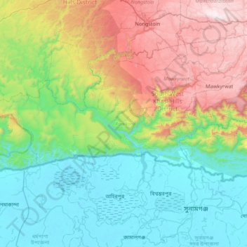
Carte topographique Ranikor
Carte interactive
Cliquez sur la carte pour afficher l’altitude.
À propos de cette carte
Nom : Carte topographique Ranikor, altitude, relief.
Altitude moyenne : 554 m
Altitude minimum : -1 m
Altitude maximum : 1’921 m
Autres cartes topographiques
Cliquez sur une carte pour visualiser sa topographie, son altitude et son relief.
Khasi Hills
India > Meghalaya > Mawshynrut
Khasi Hills, Mawshynrut, West Khasi Hills District, Meghalaya, India
Altitude moyenne : 349 m
Khliehriat
Khliehriat, East Jaintia Hills District, Meghalaya, India
Altitude moyenne : 717 m
Sonapani Waterfall Cliff
India > Meghalaya > Mylliem > Shillong
Sonapani Waterfall Cliff, Lower Mawprem, Shillong, Mylliem, East Khasi Hills District, Meghalaya, 793001, India
Altitude moyenne : 1’402 m
Sohsarat
India > Meghalaya > Shella Bholaganj
Sohsarat, Shella Bholaganj, East Khasi Hills, Meghalaya, India
Altitude moyenne : 562 m
Jymmang ne Mawshamok
India > Meghalaya > Shella Bholaganj
Jymmang ne Mawshamok, Shella Bholaganj, East Khasi Hills, Meghalaya, 793108, India
Altitude moyenne : 654 m
Cherrapunji (Sohra)
India > Meghalaya > Shella Bholaganj > Cherrapunji (Sohra)
Cherrapunji (Sohra), Shella Bholaganj, East Khasi Hills, Meghalaya, 793108, India
Altitude moyenne : 1’248 m
Nongriat
India > Meghalaya > Shella Bholaganj
Nongriat, Shella Bholaganj, East Khasi Hills, Meghalaya, 793108, India
Altitude moyenne : 706 m
Mawlynnong
Mawlynnong, Pynursla, East Khasi Hills, Meghalaya, India
Altitude moyenne : 425 m
South Garo Hills District
South Garo Hills District, Meghalaya, India
Altitude moyenne : 281 m