
Carte topographique Town of Jacksonport
Carte interactive
Cliquez sur la carte pour afficher l’altitude.
À propos de cette carte
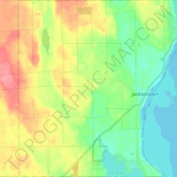
Nom : Carte topographique Town of Jacksonport, altitude, relief.
Lieu : Town of Jacksonport, Door County, Wisconsin, United States (44.93687 -87.27565 45.02549 -87.15154)
Altitude moyenne : 205 m
Altitude minimum : 172 m
Altitude maximum : 255 m
Autres cartes topographiques
Cliquez sur une carte pour visualiser sa topographie, son altitude et son relief.
Little Sturgeon
United States > Wisconsin > Door County
Little Sturgeon, Town of Gardner, Door County, Wisconsin, United States
Altitude moyenne : 179 m
Brussels
United States > Wisconsin > Door County
Brussels, Town of Brussels, Door County, Wisconsin, 54204, United States
Altitude moyenne : 227 m
Town of Egg Harbor
United States > Wisconsin > Door County
Town of Egg Harbor, Door County, Wisconsin, 54209, United States
Altitude moyenne : 196 m
Fish Creek
United States > Wisconsin > Door County > Fish Creek
Fish Creek, Town of Gibraltar, Door County, Wisconsin, 54212, United States
Altitude moyenne : 189 m
Ellison Bay
United States > Wisconsin > Door County
Ellison Bay, Town of Liberty Grove, Door County, Wisconsin, 54210, United States
Altitude moyenne : 194 m
Sturgeon Bay
United States > Wisconsin > Door County
Sturgeon Bay, Door County, Wisconsin, 54235, United States
Altitude moyenne : 199 m
Egg Harbor
United States > Wisconsin > Door County
Egg Harbor, Door County, Wisconsin, United States
Altitude moyenne : 194 m