
Carte topographique Cleendargan
Carte interactive
Cliquez sur la carte pour afficher l’altitude.
À propos de cette carte
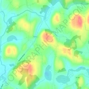
Nom : Carte topographique Cleendargan, altitude, relief.
Altitude moyenne : 78 m
Altitude minimum : 53 m
Altitude maximum : 123 m
Autres cartes topographiques
Cliquez sur une carte pour visualiser sa topographie, son altitude et son relief.
Mohill
Mohill, Mohill ED, Carrick-on-Shannon Municipal District, County Leitrim, Connacht, N41 R9T3, Ireland
Altitude moyenne : 60 m
Carrick-on-Shannon
Carrick-on-Shannon, County Leitrim, Connacht, Ireland
Altitude moyenne : 48 m
Corlea
Corlea, Drumsna ED, Carrick-on-Shannon Municipal District, County Leitrim, Connacht, Ireland
Altitude moyenne : 70 m
Leitrim
Leitrim, Kiltubbrid ED, Ballinamore Municipal District, County Leitrim, Connacht, Ireland
Altitude moyenne : 73 m
Aughavas
Aughavas, Ballinamore Municipal District, County Leitrim, Connacht, H12 YY74, Ireland
Altitude moyenne : 93 m
Carrick-on-Shannon Municipal District
Carrick-on-Shannon Municipal District, County Leitrim, Connacht, Ireland
Altitude moyenne : 63 m
Cloone
Ireland > County Leitrim > Cloone
Cloone, Ballinamore Municipal District, County Leitrim, Connacht, Ireland
Altitude moyenne : 65 m
Drumkeeran
Ireland > County Leitrim > Drumkeeran
Drumkeeran, Manorhamilton Municipal District, County Leitrim, Connacht, Ireland
Altitude moyenne : 103 m