Géolocaliser

Carte topographique Upper Langwith

Cliquez sur la carte pour afficher l’altitude.

À propos de cette carte

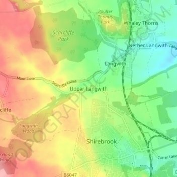
Nom : Carte topographique Upper Langwith, altitude, relief.

Lieu : Upper Langwith, Bolsover, Derbyshire, England, NG20 9RF, United Kingdom (53.19823 -1.24544 53.23823 -1.20544)

Altitude moyenne : 112 m

Altitude minimum : 62 m

Altitude maximum : 171 m

Autres cartes topographiques

Cliquez sur une carte pour visualiser sa topographie, son altitude et son relief.

Clowne

United Kingdom > England > Derbyshire > Bolsover

Altitude moyenne : 128 m

Tibshelf

United Kingdom > England > Derbyshire > Bolsover

Altitude moyenne : 152 m

Ault Hucknall

United Kingdom > England > Derbyshire > Bolsover

Altitude moyenne : 148 m

New Houghton

United Kingdom > England > Derbyshire > Bolsover

Altitude moyenne : 149 m

Langwith

United Kingdom > England > Derbyshire > Bolsover

Altitude moyenne : 121 m

South Normanton

United Kingdom > England > Derbyshire > Bolsover

Altitude moyenne : 123 m

Blackwell

United Kingdom > England > Derbyshire > Bolsover

Altitude moyenne : 130 m

Pleasley

United Kingdom > England > Derbyshire > Bolsover

Altitude moyenne : 141 m

Tibshelf

United Kingdom > England > Derbyshire > Bolsover

Altitude moyenne : 152 m

Langwith

United Kingdom > England > Derbyshire > Bolsover

Altitude moyenne : 121 m

Whitwell

United Kingdom > England > Derbyshire > Bolsover

Altitude moyenne : 99 m

Glapwell

United Kingdom > England > Derbyshire > Bolsover

Glapwell is a rural village and civil parish on the A617 road in the Bolsover District of north-east Derbyshire, The village is at the top of a steep hill at an elevation of 176m, on the western edge of the Southern Magnesian Limestone] overlooking the valley of the River Doe Lea (formerly known as the…

Altitude moyenne : 156 m

Blackwell

United Kingdom > England > Derbyshire > Bolsover

Altitude moyenne : 129 m

Équipez-vous pour votre prochaine aventure :

🛠️Outil multifonction vélo - Réparez les pannes mécaniques courantes sur le bord du chemin
🚲Mini pompe à vélo - Compacte et puissante pour regonfler vos pneus rapidement
🧤Gants de montagne tactiles - Gardez vos mains au chaud tout en manipulant votre GPS ou smartphone
📍Balises GPS - Suivi et sécurité
🎥Caméra d'action - Filmez vos descentes et vos ascensions en haute définition

En tant que Partenaire Amazon, ce site perçoit une commission sur les achats éligibles sans surcoût pour vous.