
Carte topographique Fairvale
Carte interactive
Cliquez sur la carte pour afficher l’altitude.
À propos de cette carte
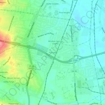
Nom : Carte topographique Fairvale, altitude, relief.
Altitude moyenne : 56 m
Altitude minimum : 32 m
Altitude maximum : 123 m
Autres cartes topographiques
Cliquez sur une carte pour visualiser sa topographie, son altitude et son relief.
Augusta Canal
United States > Georgia > Richmond County > Augusta
Augusta Canal, Augusta, Richmond County, Georgia, United States
Altitude moyenne : 80 m
Dorchester
United States > Georgia > Richmond County > Augusta
Dorchester, Augusta, Richmond County, Georgia, 30909, United States
Altitude moyenne : 90 m
Forest Acres
United States > Georgia > Richmond County > Augusta
Forest Acres, Augusta, Richmond County, Georgia, 30904, United States
Altitude moyenne : 67 m
Ellwood
United States > Georgia > Richmond County > Augusta
Ellwood, Augusta, Richmond County, Georgia, United States
Altitude moyenne : 119 m
Berckman Villas
United States > Georgia > Richmond County > Augusta > Berckman Villas
Berckman Villas, Augusta, Richmond County, Georgia, 30904, United States
Altitude moyenne : 87 m
Fort Gordon
United States > Georgia > Richmond County > Augusta > Fort Gordon
Fort Gordon, Augusta, Richmond County, Georgia, 30905, United States
Altitude moyenne : 136 m