
Carte topographique Paksong District
Carte interactive
Cliquez sur la carte pour afficher l’altitude.
À propos de cette carte
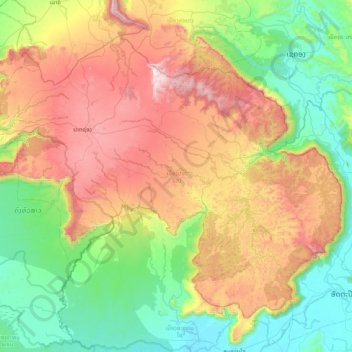
Nom : Carte topographique Paksong District, altitude, relief.
Lieu : Paksong District, Champasak Province, Laos (14.75854 106.01420 15.38971 106.82819)
Altitude moyenne : 639 m
Altitude minimum : 77 m
Altitude maximum : 1’687 m
Autres cartes topographiques
Cliquez sur une carte pour visualiser sa topographie, son altitude et son relief.
Pok
Laos > Champasak Province > Phonthong District
Pok, Phonthong District, Champasak Province, Laos
Altitude moyenne : 108 m
Sanamxai
Laos > Champasak Province > Pak Sé District
Sanamxai, Pak Sé District, Champasak Province, 16000, Laos
Altitude moyenne : 108 m
Pakse
Laos > Champasak Province > Pak Sé District
Pakse, Pak Sé District, Champasak Province, 16000, Laos
Altitude moyenne : 166 m
Phone
Laos > Champasak Province > Phone
Phone, Soukhoumma District, Champasak Province, Laos
Altitude moyenne : 96 m
Khonkaen
Laos > Champasak Province > Champassack District
Khonkaen, Champassack District, Champasak Province, Laos
Altitude moyenne : 153 m
Don Det
Don Det, Khong District, Champasak Province, Laos
Altitude moyenne : 78 m