
Faire un don
Équipez-vous pour votre prochaine aventure :
En tant que Partenaire Amazon, ce site perçoit une commission sur les achats éligibles sans surcoût pour vous.
Carte topographique Magnolia Park
Cliquez sur la carte pour afficher l’altitude.
Faire un don
Équipez-vous pour votre prochaine aventure :
En tant que Partenaire Amazon, ce site perçoit une commission sur les achats éligibles sans surcoût pour vous.
À propos de cette carte
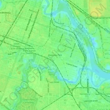
Nom : Carte topographique Magnolia Park, altitude, relief.
Altitude moyenne : 10 m
Altitude minimum : -1 m
Altitude maximum : 20 m
Faire un don
Équipez-vous pour votre prochaine aventure :
En tant que Partenaire Amazon, ce site perçoit une commission sur les achats éligibles sans surcoût pour vous.
Autres cartes topographiques
Cliquez sur une carte pour visualiser sa topographie, son altitude et son relief.
Addicks Reservoir
United States > Texas > Harris County > Houston
Addicks Reservoir is formed by a rolled earthen dam 61,666 feet (18,796 m) long and above the streambed. A 12-foot-wide (3.7 m) gravel road extends along the top of the dam. The top of the dam has a maximum elevation of 121 feet (37 m) above the NAVD 1988 and is almost 50 feet high in points. The maximum…
Altitude moyenne : 31 m
Faire un don
Équipez-vous pour votre prochaine aventure :
En tant que Partenaire Amazon, ce site perçoit une commission sur les achats éligibles sans surcoût pour vous.
original boundary of City of Houston
United States > Texas > Harris County > Houston
Altitude moyenne : 16 m
Faire un don
Équipez-vous pour votre prochaine aventure :
En tant que Partenaire Amazon, ce site perçoit une commission sur les achats éligibles sans surcoût pour vous.