
Carte topographique Redington Shores
Carte interactive
Cliquez sur la carte pour afficher l’altitude.
À propos de cette carte
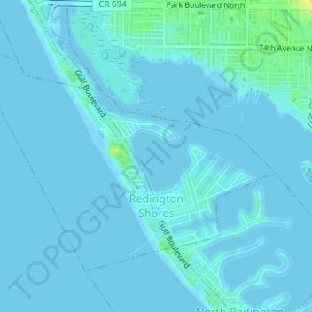
Nom : Carte topographique Redington Shores, altitude, relief.
Lieu : Redington Shores, Pinellas County, Florida, United States (27.82038 -82.84810 27.84057 -82.81703)
Altitude moyenne : 2 m
Altitude minimum : -2 m
Altitude maximum : 21 m
According to the United States Census Bureau, the town has a total area of 1.2 square miles (3.1 km2), of which 0.4 square miles (1.0 km2) is land and 0.8 square miles (2.1 km2) (67.50%) is water. According to Elevation Map Logs, the elevation of Redington Shores is just one meter above sea level.