
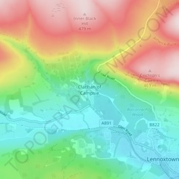
Carte topographique Clachan of Campsie
Carte interactive
Cliquez sur la carte pour afficher l’altitude.
À propos de cette carte
Nom : Carte topographique Clachan of Campsie, altitude, relief.
Altitude moyenne : 226 m
Altitude minimum : 59 m
Altitude maximum : 485 m
Autres cartes topographiques
Cliquez sur une carte pour visualiser sa topographie, son altitude et son relief.
Twechar
United Kingdom > Scotland > East Dunbartonshire
Twechar, East Dunbartonshire, Scotland, G65 9SA, United Kingdom
Altitude moyenne : 64 m
Bearsden
United Kingdom > Scotland > East Dunbartonshire
Bearsden, East Dunbartonshire, Scotland, G61 3RU, United Kingdom
Altitude moyenne : 72 m
Kirkintilloch
United Kingdom > Scotland > East Dunbartonshire
Kirkintilloch, East Dunbartonshire, Scotland, G66 1HF, United Kingdom
Altitude moyenne : 68 m
Milngavie
United Kingdom > Scotland > East Dunbartonshire
Milngavie, East Dunbartonshire, Scotland, G62 6BH, United Kingdom
Altitude moyenne : 99 m
Craigmaddie Reservoir
United Kingdom > Scotland > East Dunbartonshire > Milngavie
Craigmaddie Reservoir, Milngavie, East Dunbartonshire, Scotland, United Kingdom
Altitude moyenne : 97 m
Fauldhead
United Kingdom > Scotland > East Dunbartonshire > Lenzie
Fauldhead, Lenzie, East Dunbartonshire, Scotland, United Kingdom
Altitude moyenne : 62 m
Lenzie
United Kingdom > Scotland > East Dunbartonshire
Lenzie, East Dunbartonshire, Scotland, G66 5ER, United Kingdom
Altitude moyenne : 68 m
Milton of Campsie
United Kingdom > Scotland > East Dunbartonshire
Milton of Campsie, East Dunbartonshire, Scotland, G66 8BU, United Kingdom
Altitude moyenne : 80 m
Lennoxtown
United Kingdom > Scotland > East Dunbartonshire
Lennoxtown, East Dunbartonshire, Scotland, G66 7DB, United Kingdom
Altitude moyenne : 199 m
Bishopbriggs
United Kingdom > Scotland > East Dunbartonshire
Bishopbriggs, East Dunbartonshire, Scotland, G64 2RA, United Kingdom
Altitude moyenne : 60 m
Bardowie
United Kingdom > Scotland > East Dunbartonshire
Bardowie, East Dunbartonshire, Scotland, G62 6ES, United Kingdom
Altitude moyenne : 58 m