
Carte topographique Garden Lakes, City of Rome
Carte interactive
Cliquez sur la carte pour afficher l’altitude.
À propos de cette carte
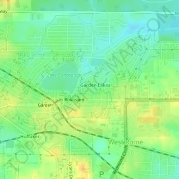
Nom : Carte topographique Garden Lakes, City of Rome, altitude, relief.
Altitude moyenne : 197 m
Altitude minimum : 184 m
Altitude maximum : 213 m
Autres cartes topographiques
Cliquez sur une carte pour visualiser sa topographie, son altitude et son relief.
Radio Springs
United States > Georgia > Floyd County
Radio Springs, Floyd County, Georgia, United States
Altitude moyenne : 243 m
Lindale
United States > Georgia > Floyd County
Lindale, Floyd County, Georgia, 30147, United States
Altitude moyenne : 229 m
Shannon
United States > Georgia > Floyd County
Shannon, Floyd County, Georgia, 30172, United States
Altitude moyenne : 211 m
Rome
United States > Georgia > Floyd County
Rome, Floyd County, Georgia, United States
Altitude moyenne : 211 m
Cave Spring
United States > Georgia > Floyd County
Cave Spring, Floyd County, Georgia, United States
Altitude moyenne : 237 m
Berryhill
United States > Georgia > Floyd County > Rome
Berryhill, Rome, Floyd County, Georgia, 30165, United States
Altitude moyenne : 207 m
Cave Spring
United States > Georgia > Floyd County > Cave Spring
Cave Spring, Floyd County, Georgia, 30124, United States
Altitude moyenne : 235 m