
Carte topographique Spa
Carte interactive
Cliquez sur la carte pour afficher l’altitude.
À propos de cette carte
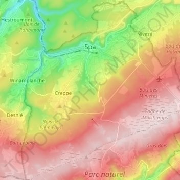
Nom : Carte topographique Spa, altitude, relief.
Lieu : Spa, Verviers, Liège, Wallonia, 4900, Belgium (50.43362 5.81536 50.51212 5.93175)
Altitude moyenne : 402 m
Altitude minimum : 192 m
Altitude maximum : 580 m
Spa has an oceanic climate that is made more continental by its higher elevation and inland position compared to other Belgian climates at lower level or closer to the sea. Spa has a relatively high precipitation year round, with tricky weather something that the Spa-Francorchamps race track is known for. The elevation also results in cooler summers and frequent winter frost along with snowfall. Spa is quite gloomy year round although averaging both a drier and sunnier climate than nearby locations Stavelot and Malmedy that are also surrounding the race track.
Autres cartes topographiques
Cliquez sur une carte pour visualiser sa topographie, son altitude et son relief.
Robertville
Robertville, Waimes, Verviers, Liège, Wallonia, Belgium
Altitude moyenne : 570 m
Baraque Michel
Belgium > Liège > Verviers > Jalhay
Baraque Michel, Jalhay, Verviers, Liège, Wallonia, 4845, Belgium
Altitude moyenne : 652 m
Arbrefontaine
Belgium > Liège > Verviers > Arbrefontaine
Arbrefontaine, Lierneux, Verviers, Liège, Wallonia, 4990, Belgium
Altitude moyenne : 448 m
Francorchamps
Belgium > Liège > Verviers > Stavelot
Francorchamps, Stavelot, Verviers, Liège, Wallonia, 4970, Belgium
Altitude moyenne : 482 m
Signal de Botrange
Belgium > Liège > Verviers > Robertville
Signal de Botrange, Robertville, Waimes, Verviers, Liège, Wallonia, Belgium
Altitude moyenne : 658 m
Thimister-Clermont
Thimister-Clermont, Verviers, Liège, Wallonia, 4890, Belgium
Altitude moyenne : 261 m
Saint Vith
Saint Vith, Verviers, Liège, Wallonia, 4780, Belgium
Altitude moyenne : 492 m