
Carte topographique Ironsides
Carte interactive
Cliquez sur la carte pour afficher l’altitude.
À propos de cette carte
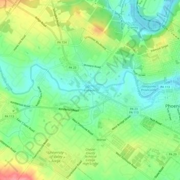
Nom : Carte topographique Ironsides, altitude, relief.
Altitude moyenne : 61 m
Altitude minimum : 27 m
Altitude maximum : 117 m
Ironsides is a populated place located within the township of Schuylkill in Chester County, Pennsylvania, United States. It has an estimated elevation of 118 feet (36 m) above sea level.
Autres cartes topographiques
Cliquez sur une carte pour visualiser sa topographie, son altitude et son relief.
Valley Forge
United States > Pennsylvania > Chester County > Schuylkill Township
Valley Forge, Schuylkill Township, Chester County, Pennsylvania, 19481, United States
Altitude moyenne : 78 m