
Carte topographique Den of Lindores
Carte interactive
Cliquez sur la carte pour afficher l’altitude.
À propos de cette carte
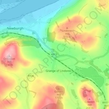
Nom : Carte topographique Den of Lindores, altitude, relief.
Altitude moyenne : 93 m
Altitude minimum : -3 m
Altitude maximum : 230 m
Autres cartes topographiques
Cliquez sur une carte pour visualiser sa topographie, son altitude et son relief.
Berryhill Farm
United Kingdom > Scotland > Fife > Grange of Lindores
Berryhill Farm, Grange of Lindores, Fife, Scotland, KY14 6HZ, United Kingdom
Altitude moyenne : 112 m