
Carte topographique Great Basin National Park
Carte interactive
Cliquez sur la carte pour afficher l’altitude.
À propos de cette carte
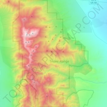
Nom : Carte topographique Great Basin National Park, altitude, relief.
Altitude moyenne : 2’352 m
Altitude minimum : 1’566 m
Altitude maximum : 3’938 m
The park derives its name from the Great Basin, the dry and mountainous region between the Sierra Nevada and the Wasatch Mountains. Topographically, this area is known as the Basin and Range Province. The park is located about 290 miles (470 km) north of Las Vegas and protects 77,180 acres (31,230 ha).
Autres cartes topographiques
Cliquez sur une carte pour visualiser sa topographie, son altitude et son relief.
Clock Spring
United States > Nevada > White Pine County
Clock Spring, Gleason Creek Road, White Pine County, Nevada, United States
Altitude moyenne : 2’522 m
Steptoe Valley
United States > Nevada > White Pine County
Steptoe Valley, White Pine County, Nevada, United States
Altitude moyenne : 2’142 m
McGill
United States > Nevada > White Pine County > McGill
McGill, White Pine County, Nevada, 89318, United States
Altitude moyenne : 1’973 m
Ely
United States > Nevada > White Pine County
Ely, White Pine County, Nevada, 89301, United States
Altitude moyenne : 2’045 m