
Carte topographique Aghafin
Carte interactive
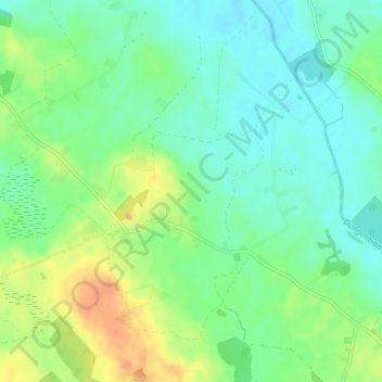
Cliquez sur la carte pour afficher l’altitude.
À propos de cette carte
Nom : Carte topographique Aghafin, altitude, relief.
Altitude moyenne : 61 m
Altitude minimum : 45 m
Altitude maximum : 85 m
Autres cartes topographiques
Cliquez sur une carte pour visualiser sa topographie, son altitude et son relief.
Castlelost
Castlelost, Castlelost ED, The Municipal District of Mullingar — Kinnegad, County Westmeath, Leinster, Ireland
Altitude moyenne : 93 m
Calverstown
Calverstown, Clonfad ED, The Municipal District of Athlone — Moate, County Westmeath, Leinster, Ireland
Altitude moyenne : 97 m
Ballygarvey
Ballygarvey, Glenlough ED, The Municipal District of Athlone — Moate, County Westmeath, Leinster, Ireland
Altitude moyenne : 66 m
Rathnew
Rathnew, Ballymorin ED, The Municipal District of Athlone — Moate, County Westmeath, Leinster, Ireland
Altitude moyenne : 134 m
The Municipal District of Athlone — Moate
The Municipal District of Athlone — Moate, County Westmeath, Leinster, Ireland
Altitude moyenne : 69 m
Mullingar
Mullingar, The Municipal District of Mullingar — Kinnegad, County Westmeath, Leinster, Ireland
Altitude moyenne : 99 m
Garrycastle
Ireland > County Westmeath > Garrycastle
Garrycastle, Athlone East Rural ED, The Municipal District of Athlone — Moate, County Westmeath, Leinster, Ireland
Altitude moyenne : 49 m
Athlone
Ireland > County Westmeath > Athlone
Athlone, The Municipal District of Athlone — Moate, County Westmeath, Leinster, N37 N1F2, Ireland
Altitude moyenne : 44 m
Mullingar
Ireland > County Westmeath > Mullingar
Mullingar, The Municipal District of Mullingar — Kinnegad, County Westmeath, Leinster, N91 FY58, Ireland
Altitude moyenne : 101 m